Hosoo Pass was a crucial route for the people living in the valley villages of southwestern Toyama and Johana Town, the closest major city. People living in these villages were largely cut off from the main Japanese society. One of the main transportation routes was along the Sho River 庄川, but the river only went through mountains in the north. A whole range of mountains encircled the southern end of Johana shielding the town from the valley.
So, the old Hosoo Pass route was established in 1887 (Meiji 20). It was fairly direct ascent up the mountains, but the road twisted enough that it was smooth travel for people and easy for horses, too. This 10 kilometer route was far more convenient than the 40 kilometer detour north following the river.

Halfway through the road, at the top of Hosoo Pass, you can clearly see Johana Town and the rest of the Takaoka and Tonami area.
These days that old route is no longer used. In 1927 (Showa 2), the Yahata Road 八幡道路 was completed. It was a paved road that went directly from Johana Town, through Hosoo Pass, and continued to the Taira and Kamitaira villages before ending in Shimonashi village on Sho River. Part of this new road was the Hosoo Pass tunnel.

On the southern end of Hosoo Pass, continuing to Taira and Shimonashi villages, the old route went over Kakuma Pass 鹿熊峠, but in 1973, the Nashitani Tunnel 梨谷トンネル was completed which decommissioned that part of the route. In 1979, construction on the Gokayama Tunnel 五箇山トンネル began and finished in 1981. The tunnel went directly through the mountains and connected with the Nashitani Tunnel. Yahata Road going through Hosoo Pass was no longer necessary.
The road is still usable today despite the occasional fallen rocks and branches from the cliffs above. Old folks still drive along the road and clear the debris. Enough preventions have been set to prevent landslides, but eventually there could be a large enough landslide to knock out the road, rendering Hosoo Pass no longer travelable from the north.
A few weeks ago, I traveled to Hosoo Pass. At the time, I knew nothing about the area, so I followed Google Map's suggestions, which lead me to several closed roads, taking too much time, and forcing me to return a few days later. That's the day that I went to that Donohara Winter Branch School. That branch school was along the Sho River to the north of Shimonashi village.
On my second trip, I left my house early at 6:30am and arrived at Hosoo Pass around 8am, an hour by highway and 30 minutes on mountain roads. Before exploring the rest of Hosoo Pass and Yahata Road, I took the side path next to Hosoo Tunnel to climb Hakamagoshiyama. I detailed that hike in a different post.
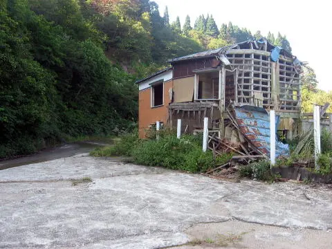
Today it's no longer a spectacle, but next to Hosoo Tunnel was a two story Tea House.

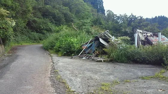
Now all that remains are 7 metal posts sticking out of the ground and a bunch of metal garbage behind them. Much of that metal garbage is the old aluminum roof of the building. There was also a refrigerator back there, and a few other things.
I have no idea when the tea house was built, but it apparently had no running water, nor any electricity of its own. For those people who traveled along the old route in the Meiji and early Showa periods, this had to have been used as a rest stop in the middle of the journey from Johana to Taira or Shimonashi. Later, after it closed, construction companies used it as an office and warehouse.
Looking around the Internet, I found a webpage that had a photo of the tea house in the year 2001. I copied the page and hosted it here as a backup. You could clearly see the 7 white metal posts holding up the front of the building, but many of the windows have been broken out, and the building doesn't look very safe.
I found some other photos other sites, too. Here's a photo of less than half of the building remaining from around 2005, I think. And then another photo from 2019 of a more distinct pile of rubble.

Now, there is so little left. I think, year after year, snow melt continued to push and move the garbage away from the site and down the mountain.
A few hundred meters away from the tunnel and tea house is the ruins of the Hosoo Pass Postal Exchange office. Finding this building is not very easy.

The Yahata Road curves along the rim of the mountain and has a steep drop off. There's a 3-meter drop to the ground from the road, and the ground is angled at 45 degrees. But apparently there's a trail down there which was the old Hosoo Pass route. Google Maps doesn't mark any kind of entry, but the OSM maps had a trail. And at those coordinates, I found a rope. The rope trails trials off into the brush going nearly straight down.
On my first trip, I did not believe that was the entry point, but I confirmed it later at home. When I came back on the weekend, I put on my worker gloves and scaled down to ground. The trail apparently hugs the road and then shoots off along the ridge of the mountain.
When there's no clear indication of a trail and you're cutting through brush, it's hard to tell if you're going the right way. I naturally followed the downward slope of the mountain, but then remembered this was not the way. I climbed up a bit, using the plants as handles and found a flattened spot.

As I headed in the direction that seemed correct, I noticed a red flag on a tree. Okay, I am actually going the right way.
Most of the trail was completely covered in brush, but there were the occasional stone and cement bricks along the path. The trail did hug the road for a little bit before heading off in the direction of the mountain ridge.
And after 10 or 15 minutes, the ruins poked through the brush in front of me.


Inside the ruins was a large painted board that detailed the history of Hosoo Pass and the Post Office. I transcribed the board and put a translation on this page.
When the Taira Post Office was established in Shimonashi in 1872 (Meiji 5), the Postal Corps 郵送隊 was also established. The Postal Corps was a group of people who lived in the villages of Taira and Shimonashi. This group of people would gather all the mail for the day and physically hike up to Hosoo Pass and down to Johana. They would collect the mail at Johana, and then return to Taira Post Office. Each person carried a maximum of 18 kilograms of mail and packages.
They did this 20 kilometer round trip every day, even in winter. When the traveled the formed a line of people. Sometimes in winter, blizzards would be so strong that it was difficult for the mail carriers to see the next person in front of them. They constantly had to sound off to make sure no one was left behind.
A few years later in 1887, the old Hosoo Pass route opened which made this travel must easier and faster. Again, in 1927 the paved road, Yahata Road, was opened which made travel more convenient in summer, and now mail could be transported by trucks. But the Postal Corps still transported the mail by foot in winter.

In 1945, ths Hosoo Pass Postal Exchange Office was built. Now, the Postal Corps had two teams. Both teams who would leave Taira and Johana post offices at 9am and meet here. Parcels and Mail would be exchanged between both teams. And then, they'd return to their towns. This cut travel time in half, but required more workers.
In 1955, as Japan experienced significant economic growth, many temporary workers were hired to match the workload. However, by 1971, the villages of Taira, Ueda, and all the areas around Shimonashi experienced significant depopulation. The current members of the corps were aging, and young people moved away to live in larger cities. The postal corps was abolished that year.
And again, the Nashitani and Gokayama tunnels were completed in 1973 and 1981, which made the road obsolete.

The brickwork and cement structure is still holding after 80 years, but all of the metalwork has rusted, and the roof of the office building has collapsed. Part of the roof still protects the signboard from the weather, though.
I took a few more pictures and then returned to the road. Out of the entrance to the Postal Exchange, the old route branches up and down the mountain. I wasn't paying close attention, but I managed to go the right way.
Moving along the ridge of the mountain, I came to the area underneath the paved road. The old route snaked along with the road until it came to that 3-meter drop off with the rope. But, I figured that I could just ascend anywhere that seemed easy enough to reach the road.

So, this looked like a good spot. I grabbed the trees and climbed up. With each step, I grabbed the next bit of plants coming out of the ground. Often I would lose my footing and slip down, but I was able to keep advancing and pulling myself up. Inch by inch, I finally saw the outline of the road and had my exit in front of me.
I moved along the 3-meter drop off until some plants were high enough to vault me up to a guardrail pipe and then I yanked myself up onto the road.

Maybe I should have shimmied along the road back to the rope, but I was back to civilization, and back on easy street. I returned to my car and continued down towards Johana to meet the Gokayama Tunnel.
The road continued to snake along the edge of the mountain. Occassionally I would have to squeak my car to the side to let another car pass. Lots of people were using the road today. I'm not sure why.

Eventually around a corner of the mountain road, this structure came into view.

At first, I had no idea what this was. A small stream was flowing over part of it, so I thought it was a hydroelectric plant, using the natural spring of the mountain for power. There was an occasional whirring sound, too, which I thought it was a turbine or some kind of internal machinery.
The northern side of the structure had plastic windows, several of which were broken. I took a look inside, and a car whizzed by! Ah... I checked the map. This was part of the Gokayama tunnel.
Back at the large square garage-looking door, one of the emergency exits was not locked, and I could go inside.

This was about a kilometer into the 3km tunnel. The road wasn't super busy, but cars whizzed by every minute or so. Next to the emergency exit was an SOS phone. Wikipedia mentions that the Gokayama tunnel was built in two parts, so maybe this was the half point of its construction.
I took some photos, and then returned to my car. I continued to the end of Yahata Road, next to the mouth of the tunnel.

There was some weird art structure nearby, but this was the end of Yahata Road.
After 6 hours of hiking and driving around the old road, I went to Shimonashi for lunch. Sakaide was a small family owned restaurant in the center of Shimonashi village. They had the standard dishes of Udon, Soba, and Rice Bowls.
On the menu, I noticed that they served bear meat in their dishes, so I ordered the Bear Meat Soba, or くま肉そば.
The soba was great, although soba is always great. I don't know how it stood apart from other soba I've had before. In the soba were chunks of cooked bear meat. It also wasn't really remarkable. They tasted like cuts of beef. It was good, but I think buying the mountain vegetable soba 山菜そば would've probably been better. Either way, it was exactly the meal I wanted for lunch. :)

When driving down the highways and motorways of Japan, there are so many side roads that go off along mountains or continue into forests. I have driven past hundreds of these roads and barely given a thought to where they lead.
Much like this case, they are often the original old roads that snaked around the mountain before tunnels were built. Also, these roads traveled to villages that once were and are no longer.
| 6:30ish | Left Home | ||
| 8:00am | by car 車 | Arrived at Hosoo Pass Tunnel | 36°26'51.0"N 136°53'48.4"E |
| 8:25am | by car 車 | Hiking Hakamagoshiyama | 36°25'54.3"N 136°52'47.7"E |
| 10:00am | walking 歩く | Back to Car | 36°25'56.6"N 136°52'49.8"E |
| 10:15am | by car 車 | Tea House Ruins | 36°26'53.1"N 136°53'51.9"E |
| 10:30am | walking 歩く | (Jumping down the cliff) | 36°26'56.2"N 136°54'01.4"E |
| 10:45am | walking 歩く | Finding the Post Office | 36°27'03.9"N 136°54'00.2"E |
| 11:05am | walking 歩く | Leaving the Post Office | |
| 11:15am | walking 歩く | Climbing to the Road | 36°26'59.7"N 136°54'03.8"E |
| 11:25am | walking 歩く | Back to Car | 36°26'53.1"N 136°53'51.9"E |
| 11:50am | by car 車 | Highway Emergency Exit | 36°27'37.7"N 136°54'39.3"E |
| 12:15pm | by car 車 | Back to the Main Highway | 36°27'54.0"N 136°54'11.7"E |
| 12:30pm | by car 車 | Sakaide 坂出 (for lunch) | 36°25'59.3"N 136°56'54.8"E |


